Filtering in Remote Sensing. Convolution. Edge enhancement. Low pass filter and High-pass filter

Filtering in Remote Sensing. Convolution. Edge enhancement. Low pass filter and High-pass filter
Spatial filtering is a technique used in remote sensing to enhance the spatial resolution of an image. This is typically done by using a mathematical algorithm to process the raw data collected by the remote sensing instrument, with the goal of reducing noise and improving the overall quality of the image.
Spatial frequency in remote sensing refers to the density of spatial details or features in an image. It is a measure of how quickly the intensity or brightness of an image changes over a given distance. High spatial frequency indicates a high density of fine details or edges in an image, while low spatial frequency indicates a low density of fine details or edges. Spatial frequency is an important concept in remote sensing because it can affect the ability to detect and interpret features in an image. It can also be used to evaluate the quality and usefulness of an image for certain types of analysis.
One common type of spatial filtering used in remote sensing is called convolution. This involves applying a mathematical kernel, also known as a filter, to each pixel in the image. The kernel is a small matrix of numbers that is used to weight the surrounding pixels in the image. The weighted values are then summed and assigned to the central pixel, effectively smoothing out any noise or other artifacts in the image.
In remote sensing, a kernel is a small matrix of numbers that is used in image processing operations. Kernels are commonly used in image convolution, which is a technique for applying a mathematical operation to an image to enhance or extract features from the data. Kernels are typically defined by a set of coefficients that specify the weighting of the input pixels in the convolution operation. The kernel is applied to the image by sliding it across the image and performing the convolution operation at each pixel location. This results in a transformed image that has been processed by the kernel. Kernels are commonly used in remote sensing applications to perform operations such as smoothing, edge detection, and sharpening.
Another type of spatial filtering is known as edge detection. This is a type of spatial filtering that is specifically designed to enhance the edges in an image, making them more pronounced and easier to identify. This can be useful for identifying features such as roads, buildings, and other man-made structures in an image.
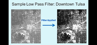
A low pass filter in remote sensing is a type of filter that is used to remove high frequency noise from an image. This noise can be caused by factors such as atmospheric conditions, sensor noise, and other sources of interference. The low pass filter works by selectively allowing low frequency signals to pass through while blocking or attenuating high frequency signals. This results in a smoother and clearer image, with reduced noise and improved signal-to-noise ratio. Low pass filters are commonly used in remote sensing applications to improve the quality of images and to enhance the visibility of features and patterns in the data.
A high-pass filter in remote sensing is a type of filter that is used to enhance or highlight high frequency features in an image. This can be useful for identifying fine details, sharp edges, and small objects in the data. The high-pass filter works by selectively allowing high frequency signals to pass through while blocking or attenuating low frequency signals. This results in an image with enhanced contrast and sharpness, making it easier to detect and analyze features and patterns in the data. High-pass filters are commonly used in remote sensing applications to improve the visibility of small or subtle features, such as buildings, roads, and vegetation.
Sharpening in remote sensing refers to the process of increasing the spatial resolution of an image by enhancing its fine details and edges. This is typically achieved through the use of mathematical algorithms that process the image data and apply mathematical filters to sharpen the image. Sharpening can be useful for improving the visual quality of an image and making it easier to identify and interpret features in the image. It can also be useful for enhancing the usefulness of an image for certain types of analysis, such as object detection or change detection.
Smoothing in remote sensing refers to the process of reducing the spatial resolution of an image by smoothing out its fine details and edges. This is typically achieved through the use of mathematical algorithms that process the image data and apply mathematical filters to smooth the image. Smoothing can be useful for reducing the amount of noise in an image and making it easier to identify and interpret larger, more broad-scale features in the image. It can also be useful for improving the overall visual quality of an image, making it appear more aesthetically pleasing. Smoothing can also be used to reduce the file size of an image, making it easier to store and transmit.
Overall, spatial filtering is an important tool in the field of remote sensing, as it allows analysts to improve the quality and usefulness of the images collected by remote sensing instruments.


Comments
Post a Comment